
Para consulta...
_____________________________________________________________________________
Grelha de avaliação das apresentações orais (Geografia).
 _____________________________________________________________________
RECURSOS - ENSINA RTP
http://blogue.rbe.mec.pt/recursos-de-geografia-ensina-rtp-2168371
_____________________________________________________________________


Dig deeper:
A cartographic anomaly is resolved (June, 2015)
The land that maps forgot (February 2011)
_____________________________________________________________________________
Grelha de avaliação das apresentações orais (Geografia).

RECURSOS - ENSINA RTP
http://blogue.rbe.mec.pt/recursos-de-geografia-ensina-rtp-2168371
_____________________________________________________________________
4 Maps Crucial to Understanding Europe's Population Shift
Despite
economic growth in Central and Eastern Europe, the continent is still migrating
to the Northwest.
FEARGUS
O'SULLIVAN @FeargusOSull - Feb 9, 2015
Europe’s population is
shifting to the Northwest. The GDP in its more easterly nations seems to be
booming, while the countryside and many smaller cities continue to empty at the
expense of the great conurbations. And while Europe’s southern nations continue
to suffer under austerity, cities around the Mediterranean are nonetheless
among the fastest growing in terms of population. These are just some of the
key demographic shifts outlined in arecent report [PDF] from Bloomberg
Philanthropies and LSE Cities. While the report focuses overall on the 155
submissions made to last year’s first everEurope-based Bloomberg Philanthropies Mayors
Challenge, its data provides a fascinating snapshot of a
continent on the move.
Go East?

While they’re often
depicted as the continent’s poor relations, it’s actually the states of Central
and Eastern Europe where per capita GDP has grown fastest. Calculating an
average from growth rates between 2003 and 2013, the speediest developers
overall are Lithuania, Moldova and Albania. Within this broad region, big
cities are generally growing at a slower rate than the countries that contain
them. There are admittedly some exceptions to this rule. Bulgaria’s and
Slovakia’s respective capitals, Sofia and Bratislava, are notably powering
ahead of their hinterlands. Meanwhile austerity-hit Southern Europe continues
to languish (as does Ireland), with second tier cities like Southern Italy’s
Messina and Greece’s Larissa particularly hard hit. Had the survey period
covered only the five years prior to 2013, it’s likely the GDP drops would have
been sharper still.
The pink glow that this map gives Europe’s eastern end
shouldn’t lull us into a falsely rosy view of the region, however.
Transylvania’s Cluj-Napoca, for example, has seen an impressive GDP boom over
the past decade, with an average annual rise of 4.1 percent. This still places
GDP per capita in this apparent boomtown at €5,840 ($6652), which is barely
more than 10 percent of Copenhagen, where per capital GDP is €56,100 ($63,900).
If the East is rising, it still has a long way to go.
No Work
for the Young

This youth
unemployment map highlights some predictable bleak spots (almost two-thirds of
under-25 year-old Athenians and Barcelonans are out of work) but also some
surprises. Even cities that are otherwise doing fairly well are having serious
trouble integrating young people into their workforces. Wealthy Stockholm, for
example, has a shockingly high youth unemployment rate of 30 percent. There’s
also major disparity from city to city, especially in the U.K. Here cities such
as Sheffield, with a youth unemployment rate of 35 percent, are within a few
hours of Edinburgh and Cambridge, where young citizens find it far easier to
find jobs.
Big City
Drain

If Europe’s big cities
are growing, it’s often because they are attracting people from outside—not
just immigrants, but migrants from within the same countries. That’s why the
Albanian capital Tirana has grown so much (with an annual population growth
rate of 2.8 percent) even as its surrounding country has become depopulated. By
volume, this migration flows to the largest cities, but the list of cities that
have grown most by proportion isn’t a simple case of the usual suspects. After
Tirana, Larissa and the Athens suburb of Acharnes, the highest proportional
climbers are actually Manchester, Utrecht and Brussels—none of which earn a
high ranking in the European megatropolis league. What these cities all have in
common is relatively affordable property, one possible reason why they may have
proportionally outpaced more expensive cities such as London and Paris.
Migrating
to the Northwest

The European cities
currently receiving the most migrants born in other countries are
overwhelmingly clustered in countries that border the North Sea and English
Channel. London may have the largest total number, but the greatest proportion
in relation to the rest of the population is actually to be found in the Swiss
city of Lausanne. As a relatively affordable part of a wealthy region with a
low birth rate, French Switzerland’s second city has in fact been attracting
migrants (initially from Southern Europe) for decades. And the lack of
migration to Central and Eastern Europe is actually something of a headache for
those countries, as it means that every talented worker who leaves (and many do)
is especially hard to replace.
Taken in isolation, the picture all this leaves can be
partly misleading. The cluster of German cities swelled by migration gives the
impression of a country facing a demographic spike. In fact, the country’s low
birthrate is causing the country’s population as a whole to fall, a fact that
immigration to its larger cities is only partly managing to mitigate.
_____________________________________________________________________________
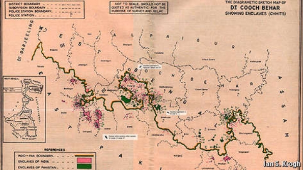
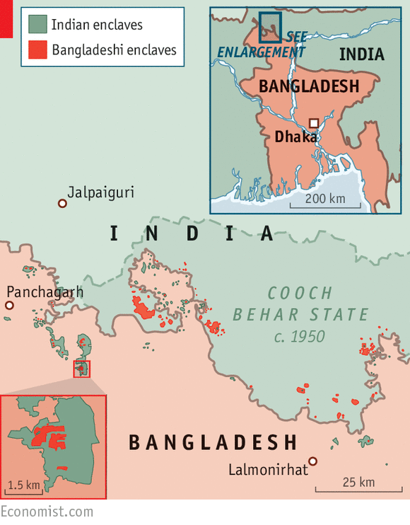
The Economist explains
Why India and Bangladesh have the world's craziest border

THIS year marks a watershed in the annals of bizarre geography. On July 31st India and Bangladesh will exchange 162 parcels of land, each of which happens to lie on the wrong side of the Indo-Bangladesh border. The end of these enclaves follows an agreement made between India and Bangladesh on June 6th. The territories along the world’s craziest border include the pièce de résistance of strange geography: the world’s only “counter-counter-enclave”: a patch of India surrounded by Bangladeshi territory, inside an Indian enclave within Bangladesh. How did the enclaves come into existence?
India and Bangladesh share a 4,100km (2,500-mile) border, hastily drawn around one of the most densely populated places on earth in 1947. Because of endless zigging and zagging it constitutes the world’s fifth-longest. The parcels to be exchanged are 111 Bangladeshi and 51 Indian enclaves clustered on either side of Bangladesh’s border with the district of Cooch Behar, in the Indian state of West Bengal. The enclaves are invisible on most maps; most are invisible on the ground too. But they became an evident problem for their 50,000-odd inhabitants with the emergence of passport and visa controls. Independent India and Bangladesh—part of Pakistan until 1971—each refused to let the other administer its exclaves, leaving their people effectively stateless.
Legend has it that the enclaves were formed as a result of a series of chess games played between two maharajas centuries ago (the chunks of land were used as wagers). They were later attributed to a drunken British officer who supposedly spilt drops of ink on the map when drawing the India-Pakistan border in 1947. According to Reece Jones, a political geographer, the plots were cut from larger territories by treaties signed in 1711 and 1713 between the maharaja of Cooch Behar and the Mughal emperor in Delhi, bringing to an end a series of minor wars. Armies kept the territory they controlled, inhabitants paid taxes to their respective feudal rulers and people moved freely across a quiltwork patterned by feudal warfare. Fifty years later, efforts by the British East India Company to clear up the messy map failed when their residents opted to stay put.
It was partition, the division of India and Pakistan, that turned the enclaves into a no-man’s-land. The Hindu maharaja of Cooch Behar chose to join India in 1949 and he brought with him the ex-Mughal, ex-British possessions he inherited. Enclaves on the other side of the new border were swallowed (but not digested) by East Pakistan, which later became Bangladesh. It was not until 1974 that the two countries first agreed to fix this zany borderland. India agreed to forgo compensation for a net loss of territory that is roughly half the size of Hong Kong Island (or 2,000 cricket stadiums). But weak governments and nationalism thwarted India’s progress. In May 2015, 41 years later, its parliament finally passed a constitutional amendment required to cede land to Bangladesh and resolve the anomaly.
Erasing the enclaves will have three main effects. The first will be felt primarily by residents, who can now choose which country to join, acquiring basic benefits of citizenship in the process. The process will allow India and Bangladesh to focus on weightier matters. Finally, in vanishing from the borderlands of Bengal, the world’s enclaves have taken a flying leap towards extinction. From this summer, there will be 49 extraterritorial patches left anywhere, mainly in western Europe and on the fringe of the former Soviet Union. Most of the world’s enclaves will have disappeared overnight.
Dig deeper:
A cartographic anomaly is resolved (June, 2015)
The land that maps forgot (February 2011)
_____________________________________________________________________________
Créer et jouer au Cache-Cache Numérique (Géocaching)

Vous avez l’esprit aventurier, vous cherchez une activité originale à faire en famille, avec vos élèves, en couple ou entre amis tout en découvrant des sites en dehors des sentiers battus, des sites connus des habitants ? Faîtes du geocaching : une réelle chasse aux trésors à l'aide d'outils numériques !! Une visite ludique du patrimoine, nombreuses caches sur la Grande Guerre.
Accessible à tout public, toute l’année. Site en plusieurs langues, le guide du jeu.
Le site Web : http://www.geocaching.com/education/
Un exemple dans l'Oise sur la Grande Guerre 1914-1918 :
Une chasse au trésor moderne
Une chasse au trésor moderne
L’objectif ? Dénicher des petites boites étanches nommées « caches » où se trouvent un carnet de passage et des objets surprises. Laissez-y vos impressions et replacer la boite au même emplacement : cela aidera les prochains aventuriers à la trouver de nouveau.
De nombreuses cachettes autour de sites 14-18 à Rethondes, Noyon, Nampcel, Tracy-le-Mont, Confrécourt, Montigny, Thiescourt, Thourotte…
Exemple de cache à Rethondes :
http://www.geocaching.com/geocache/GC3Q7X1_rethondes
http://www.geocaching.com/geocache/GC3Q7X1_rethondes
Voilà l'adresse pour trouver les autres caches (exemple : dans le champ par adresse taper Noyon,oise,France et go):
http://www.geocaching.com/seek/default.aspx
Equipement : GPS, smartphone ou tablette et téléchargez l’application géocaching sur Google play ou apple store. http://www.geocaching.com
Steve Quirion vous propose une utilisation de Géocaching au 1er cycle du primaire
J'explore mon quartier, Situation d'apprentissage et d'évaluation (SAÉ)
J'explore mon quartier, Situation d'apprentissage et d'évaluation (SAÉ)
Pour aller plus loin :
Créer chasses au trésor, énigmes, jeu de piste, enquête mystère… sur tablette ou smartphone
Démonstration du principe Géocaching en vidéo :
____________________________________________________________________
Geored
Geored
O que é Geored?
______________________________________________________________________________
Worldmapper is a collection of world maps, where territories are re-sized on each map according to the subject of interest.
There are now nearly 700 maps. Maps 1-366 are also available as PDF posters. Use the menu above to find a map of interest. In 2009 we added a series of maps of the world's population using a gridded cartogram approach: Worldmapper Population Atlas
If you are interested in more background on map projections, read the short introductions about Worldmapper and map projections andgridded cartograms as a map projection.
______________________________________________________________________________
______________________________________________________________________________

_____________________________________________________________________________
Microsoft WorldWide Telescope
Espreitem... Vale a pena!
 Microsoft WorldWide Telescope na web
WWT é uma programa que converte um computador com Windows numa espécie de telescópio virtual, mostrando as melhores imagens do espaço obtidas com diversos instrumentos terrestres e espaciais.
http://pelanatureza.pt/
_________________________________________________________________________________
Nations Unies
http://www.un.org/
_________________________________________________________________________________

Site oficial da International Co-operative Alliance
http://ica.coop/en
_________________________________________________________________________________

Milhares de estatísticas sobre municípios, Portugal e a Europa
http://www.pordata.pt/Portugal
_________________________________________________________________________________

Fotos, mapas...do mundo.
http://www.alovelyworld.com/index2.html
_________________________________________________________________________________

http://www.esa.int/Education
________________________________________________________________________________

http://www.eea.europa.eu/pt
________________________________________________________________________________
AMBIENTE ONLINE
http://www.ambienteonline.pt/
________________________________________________________________________________

http://www.apgeo.pt/
________________________________________________________________________________

http://geotic.aprofgeo.pt/
________________________________________________________________________________

Revista Portuguesa de Geografia. Encontras todos os números da revista editados até ao momento.
http://www.ceg.ul.pt/finisterra/
_______________________________________________________________________________

Cartografia de conflitos no mundo contemporâneo.
http://www.monde-diplomatique.fr/
_______________________________________________________________________________
_________________________________________________________________________________
Pela Natureza
Pela Natureza
Pela Natureza que pretende ir ao encontro das necessidades de uma sociedade
cada vez mais global preocupada com um futuro sustentável.
As preocupações ambientais e sua consciencialização trouxeram ao mercado,
novas e dinâmicas empresas que visam oferecer ao consumidor produtos que tenham
uma preocupação acrescida com o ambiente.
Contudo verificámos que este crescimento do mercado tem vindo a ser
acelerado e disperso, dificultando ao consumidor o acesso a determinados
produtos que por vezes são desconhecidos para ele.
Assim, surge pelanatureza.pt, um projecto que tem como objectivo criar uma
plataforma informativa na web de consulta ao mercado, que permita concentrar
num único sítio toda a oferta de produtos e serviços directamente relacionados
com as questões ambientais.
_________________________________________________________________________________
Nations Unies
Résolution adoptée par l’Assemblée générale le 20 décembre 2010 [sur la base du rapport de la Deuxième Commission (A/65/436 et Corr.1)] 65/151. Année internationale de l’énergie durable pour tous.
_________________________________________________________________________________
Site oficial da International Co-operative Alliance
http://ica.coop/en
_________________________________________________________________________________
Milhares de estatísticas sobre municípios, Portugal e a Europa
http://www.pordata.pt/Portugal
_________________________________________________________________________________
Fotos, mapas...do mundo.
http://www.alovelyworld.com/index2.html
_________________________________________________________________________________
The European Space Agency (ESA) is Europe's gateway to space. Its mission is to shape the development of Europe's space capability and ensure that investment in space continues to deliver benefits to the citizens of Europe and the world. Since ESA was created, more than 30 years ago, one of its most important tasks has been to inform the public about the latest advances and discoveries in the space field, and to develop programmes that will inspire young people to pursue careers in science and technology. The aim of ESA's online resources for educators is to help young Europeans, aged from 6 to 28, to gain and maintain an interest in science and technology, with the long-term objectives of contributing towards the creation of a knowledge-based society and ensuring the existence of a qualified workforce for the Agency that will ensure Europe's continued leadership in space activities.
________________________________________________________________________________
A enciclopédia ambiental da Agência Europeia do
Ambiente (EEA), a EPAEDIA, apresenta notícias e informação ao público em geral,
de forma simples e divertida. Nela poderá encontrar um vasto conjunto de
informações permanentemente atualizado sobre os atuais problemas ligados ao
ambiente: poluição do ar, recursos naturais, arquitetura sustentável, solos,
água, biodiversidade, etc.
http://www.eea.europa.eu/pt
________________________________________________________________________________
AMBIENTE ONLINE
O portal Ambiente online
assume-se como o centro de serviços de informação, comunicação e divulgação do
mercado do ambiente, especializado em dar resposta às necessidades do sector.
Com actualização diária de informação, disponibiliza os seguintes suportes
online: notícias, agenda, directório de empresas, produtos e serviços e
ligações a sítios de interesse.
________________________________________________________________________________
Página oficial da Associação Portuguesa de
Geógrafos com informações relativas aos Congressos de Geografia Portuguesa e
Colóquios Ibéricos de Geografia e conteúdos da revista INFORGEO.
http://www.apgeo.pt/
________________________________________________________________________________
GEOTIC – À Descoberta de Portugal. Conteúdos:
Terra: estudos e representações; meio natural; população e povoamento;
actividades económicas; contrastes de desenvolvimento; ambiente e sociedade; à
descoberta de Portugal, da Europa e do Mundo.
http://geotic.aprofgeo.pt/
________________________________________________________________________________
Revista Portuguesa de Geografia. Encontras todos os números da revista editados até ao momento.
http://www.ceg.ul.pt/finisterra/
_______________________________________________________________________________
Cartografia de conflitos no mundo contemporâneo.
http://www.monde-diplomatique.fr/
_______________________________________________________________________________
Sem comentários:
Enviar um comentário